 |
VILAS CountyWISCONSINA WIGenWeb Project |
|
|
|
VILAS CountyWISCONSINA WIGenWeb Project |
|

|
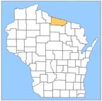
MAPS OF VILAS COUNTYOn this SiteTwo Outline Maps Showing the Boundaries of Towns of Vilas County1898 Map of Oneida, Vilas and Range 4 of Iron counties 1908 Platbook of Wisconsin Lake Region Map of Forest County 1920"s Platbook Maps 1921 Wisconsin Map, 23 pages Giving all Main and Secondary Highways, Railroads On Other SitesCurrent WI State Road Maps are available from Wisconsin Department of Transportation They also have large wall maps for sale and county maps that can be downloaded in pdf format. Link to the WIGenWeb- List of Online Map Resources
|
| . |